


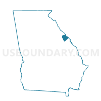
073051 - DAMASCUS BAPT CHURCH Voting District, Columbia County, Georgia
About
Outline

Summary
| Unique Area Identifier | 560991 |
| Name | 073051 - DAMASCUS BAPT CHURCH Voting District |
| County | Columbia County |
| State | Georgia |
| Area (square miles) | 25.33 |
| Land Area (square miles) | 15.14 |
| Water Area (square miles) | 10.19 |
| % of Land Area | 59.77 |
| % of Water Area | 40.23 |
| Latitude of the Internal Point | 33.66745620 |
| Longtitude of the Internal Point | -82.30157220 |
Maps


Graphs
Select a template below for downloading or customizing gragh for 073051 - DAMASCUS BAPT CHURCH Voting District, Columbia County, Georgia


Neighbors
Neighoring Voting District (by Name) Neighboring Voting District on the Map
- 073040 - EUBANK/BLANCHARD Voting District, Columbia County, GA
- 073050 - BURKS MOUNT FIRE Voting District, Columbia County, GA
- 1813-B - TABERNACLE Voting District, Lincoln County, GA
- 1814-B - MARTINS CROSSROAD Voting District, Lincoln County, GA
- Clarks Hill Voting District, McCormick County, SC
Top 10 Neighboring County Subdivision (by Population) Neighboring County Subdivision on the Map
- Appling CCD, Columbia County, GA (11,194)
- South Lincoln CCD, Lincoln County, GA (4,289)
- Parksville CCD, McCormick County, SC (2,118)
Top 10 Neighboring Unified School District (by Population) Neighboring Unified School District on the Map
- Columbia County School District, GA (124,053)
- McCormick County School District, SC (10,233)
- Lincoln County School District, GA (7,996)
Top 10 Neighboring State Legislative District Lower Chamber (by Population) Neighboring State Legislative District Lower Chamber on the Map
Top 10 Neighboring State Legislative District Upper Chamber (by Population) Neighboring State Legislative District Upper Chamber on the Map
Top 10 Neighboring 111th Congressional District (by Population) Neighboring 111th Congressional District on the Map
Top 10 Neighboring Census Tract (by Population) Neighboring Census Tract on the Map
- Census Tract 9702, Lincoln County, GA (4,289)
- Census Tract 304.01, Columbia County, GA (2,615)
- Census Tract 9203, McCormick County, SC (2,118)